Alumnus Zak Kassas on Navigation, Spoofing and the Future of GPS
The PECASE awardee, professor and transportation center leader offers invaluable insights on the field.
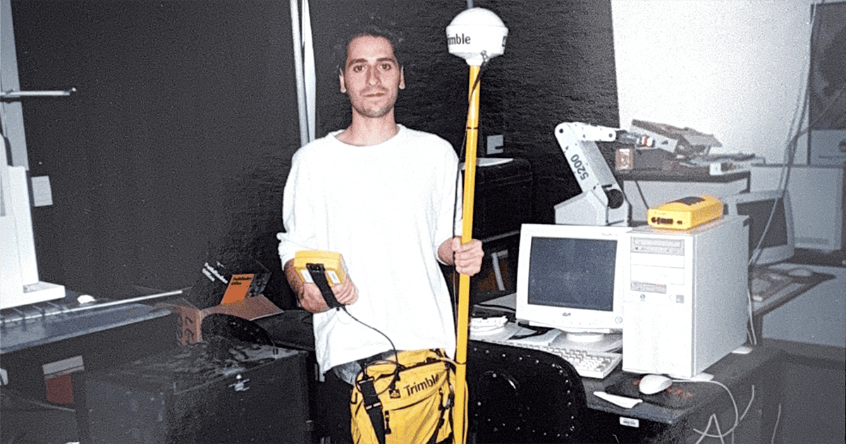
Well before the likes of Google Maps were available for public use, one LAU engineering student had the idea to map out Byblos using GPS signals for his final-year project. Driving through the night with gear mounted on the roof of his car, he collected data to validate his research findings and was adamant about producing a digital map of the city.
Alumnus Zak Kassas (BE ’01) back then had only just started feeding his scientific curiosity and nothing could stop him, not even some raised eyebrows from bystanders. Together with Professor Samer Saab, he co-authored two research papers and published them at a conference and a scientific journal—considered a rare breakthrough at the time for an undergraduate student.
Today, Dr. Kassas is the Transportation Research Center (TRC) Endowed Chair in Intelligent Transportation Systems and a Professor of Electrical and Computer Engineering at The Ohio State University. He is also the Director of the US Department of Transportation Center for Automated Vehicles Research with Multimodal AssurEd Navigation (CARMEN) as well as the Director of the Autonomous Systems Perception, Intelligence and Navigation (ASPIN) Laboratory.
Most recently, Dr. Kassas has been awarded the highest honor of the US Government for outstanding scientists and engineers, the Presidential Early Career Award for Scientists and Engineers (PECASE). An IEEE and an Institute of Navigation (ION) fellow, he is also a distinguished lecturer of the IEEE Aerospace and Electronic Systems Society and the IEEE Intelligent Transportation Systems Society. Ranked as the top scholar globally in navigation by ScholarGPS, he has authored more than 200 peer-reviewed journal and conference papers, 12 magazine articles, three invited book chapters, and 24 US patents.
In this interview, Dr. Kassas maps out the milestones that helped him earn those accolades, as well as the fast-changing nature of his field. He reflects on building effective tools to mitigate interference, spoofing and cyber-security attacks, and offers a wealth of food for thought in the field and beyond for up-and-coming researchers.
What contributed to your nomination to PECASE?
I was nominated by both the National Science Foundation and the Department of Transportation, and it caught me by a pleasant surprise. I was awarded the PECASE for “pioneering contributions to cyber-physical systems technologies for the next-generation intelligent national transportation infrastructure.”
I lead a university transportation center (UTC) that started in 2020, encompassing four universities: The Ohio State University, University of Texas at Austin, University of California Irvine, and North Carolina A&T University. The UTC was established in response to a White House executive order on “Strengthening National Resilience through Responsible Use of Positioning, Navigation, and Timing Services.” Since finishing my Ph.D. in 2014, I have been working in this field of research: mitigating GPS interference, spoofing and cyber-security attacks.
What first sparked your interest in this topic?
It started back when I was an undergraduate senior student at LAU, and first discovered the GPS hardware that Dr. Samer Saab had put in one corner of the Zakhem Engineering Hall.
I told him that I wanted to look into a topic that is both theoretical and experimental for my final-year design project, adding that “the GPS hardware in the lab seemed intriguing.” Dr. Saab said that he has an “idea to put this GPS hardware into good use” to prove a new concept for future intelligent transportation systems. I assembled the hardware—a Trimble system—and started running experiments at a time when there were no digital maps of the city and GPS was not yet widely known, in 2001.
I mounted the bulky hardware on the roof of my car and used the GPS constellation over Byblos to map out two extremes: the least number of satellites at 2:00 a.m., which causes issues with navigation, and, alternatively, the greatest number of satellites at 4:30 a.m. which is ideal for mapping.
I turned into a night owl for two months to prove my findings through repeatability, often going back to the lab between trips to process the data.
The outcome was co-publishing two papers with Dr. Saab in a top conference (IEEE Intelligent Vehicles Symposium) and a top journal (IEEE Transactions on Intelligent Transportation Systems). When I arrived in the US, I got to talk to one of the gurus of control and intelligent transport systems, Dr. Umit Ozguner. As he learned about my experience, he hired me as a graduate research assistant, which helped me fund my master’s degree at The Ohio State University. My academic focus during my master’s studies shifted to estimation.
After graduating, I worked in research and development at National Instruments Corporation, developing LabVIEW real-time control systems and signal processing algorithms. Simultaneously, I completed a second master’s in aerospace engineering at the University of Texas at Austin (UT). Afterwards, I finished a PhD at UT in Electrical and Computer Engineering. I vividly remember attending a seminar by Dr. Todd Humphreys, who became my PhD advisor at UT. During his interview for a faculty position, he presented his research about GPS, which brought me back to my undergraduate passion, this time with more knowledge in control, estimation and signal processing.
Since 2014, I have been contributing to building technologies for when GPS is lost and/ or spoofed.
How did the field of GPS evolve, and what do you think will be the research focus for the years to come?
GPS became the dominant navigation technology when the US Government gave people this free, worldwide service, and it became integrated into so many aspects of our lives.
However, people discovered that there are inherent vulnerabilities of GPS such as using it indoors or in deep urban canyons. They also realized that GPS can be interfered with, spoofed or jammed. That is when governments started to pose security questions, suggesting to build their own independent or new systems. Today, a lot of money continues to be invested in these efforts.
Some nations and big tech giants are planning to launch satellites dedicated to navigation to patch the issues with GPS, while others are establishing their own ground infrastructure. However, I feel that these approaches are solving the issues with GPS with the same thinking that created the original issues: whatever one builds is prone to vulnerability. My thinking on this is to adopt a sustainable, more economical approach: diversify and reuse what we already have. Essentially, we could exploit the plethora of communication signals around us—which are referred to as signals of opportunity—whether they are coming from space or terrestrially. In my opinion, repurposing the communication infrastructure, while integrating sensing and navigation, is the way forward.
When I started working on navigation with signals of opportunity, people thought it was a dream project. Over the past decade, it became a hot research topic in academia, and is being adopted by many government agencies and industry stakeholders.
You have mentored a lot of LAU alumni as graduate and doctoral students. Could you tell us about your experience working with them?
I have four students at Ohio State who are LAU alumni working with me right now. When I first started the lab, one of my first PhD students, Joe Khalife (BE ’11; MS ’14), was instrumental in helping me set it up. He is one of the most accomplished graduates in the field. He received the IEEE Position, Location, and Navigation Symposium (PLANS) Best Student Paper Award in 2016, the IEEE Walter Fried Award in 2018, and the IEEE Aerospace and Electronic Systems Society Robert T. Hill Best Dissertation Award in 2021. In fact, LAU graduates have dominated the Best Paper Award at PLANS since 2016.
I have recently had high-level visitors from government and industry visit my lab who have been amazed by the research of these LAU alumni. Those include Sharbel Kozhaya (BE ’21), Joe Saroufim (BE ’22) and Samer Hayek (BE ’22).
LAU has, aside from the solid education, brilliant minds and we should not let brilliant minds go to waste.
What advice would you offer current LAU students looking to enter the field?
Students tend to follow trends, but those might die out and cease to be attractive in a few years. One of my advisors once warned me against following a topic simply because it is currently a buzzword. My advice is to instead work in a field that you are passionate about, while trusting the guidance of an advisor who is building the future of this field.
This interview has been edited and condensed for the sake of clarity.